Arkansas City Maps
City Maps > AR Cities
 This Arkansas city maps page features a map of Little Rock, the state's capital city; it also provides access to detailed maps of cities and other places that are located in Arkansas.
Arkansas has a land area of 52,030 square miles. The state's population density is about 56.0 residents per square mile.
Little Rock Map
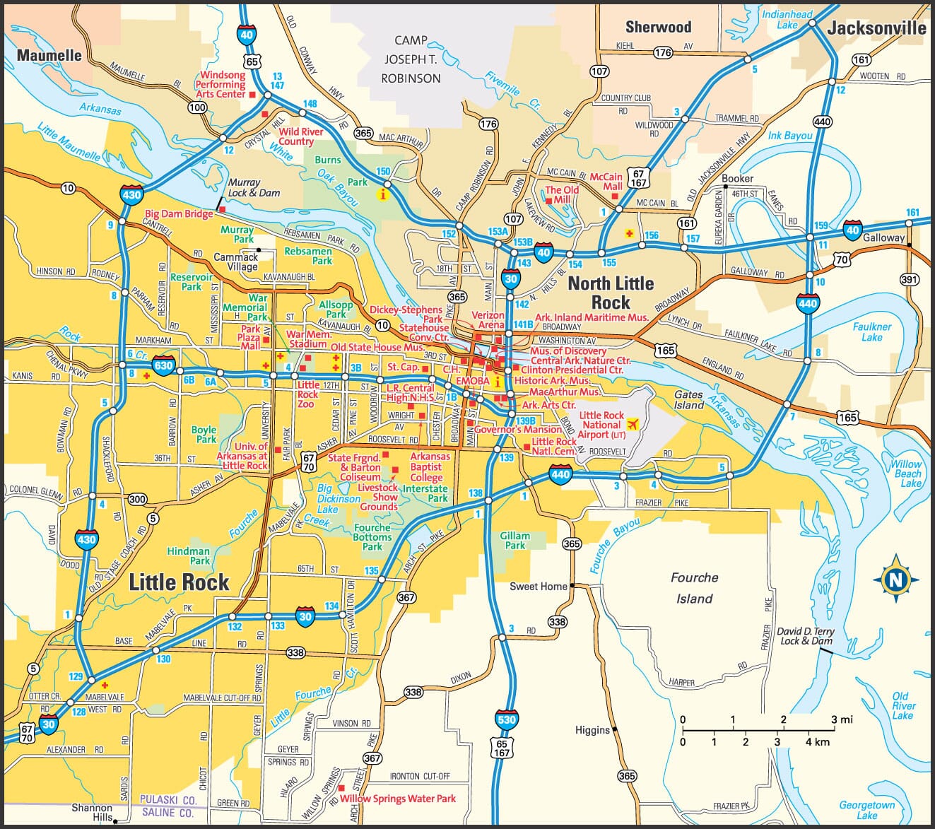
This Little Rock area map shows highways as well as major roads and points of interest in Arkansas's capital city.

Little Rock, Arkansas Area Map
Arkansas Cities and Places *
Each city map page features a locator map plus demographic information about the specific city — as well as a directory of organizations in that Arkansas city.- Benton, Arkansas Map - Located at latitude 34.56 north and longitude 92.59 west, the city of Benton had a population of 30,681 at the 2010 census.
- Bryant, Arkansas Map - Located at latitude 34.60 north and longitude 92.49 west, the city of Bryant had a population of 19,625 at the 2010 census.
- Conway, Arkansas Map - Located at latitude 35.09 north and longitude 92.44 west, the city of Conway had a population of 64,490 at the 2010 census.
- Eureka Springs, Arkansas Map - Located at latitude 36.40 north and longitude 93.74 west, the city of Eureka Springs had a population of 2,086 at the 2010 census.
- Fayetteville, Arkansas Map - Located at latitude 36.06 north and longitude 94.16 west, the city of Fayetteville had a population of 80,621 at the 2010 census.
- Fort Smith, Arkansas Map - Located at latitude 35.39 north and longitude 94.4 west, the city of Fort Smith had a population of 87,351 at the 2010 census.
- Gravette, Arkansas Map - Located at latitude 36.42 north and longitude 94.45 west, the city of Gravette had a population of 2,325 at the 2010 census.
- Harrison, Arkansas Map - Located at latitude 36.23 north and longitude 93.11 west, the city of Harrison had a population of 12,943 at the 2010 census.
- Jacksonville, Arkansas Map - Located at latitude 34.87 north and longitude 92.11 west, the city of Jacksonville had a population of 28,808 at the 2010 census.
- Jonesboro, Arkansas Map - Located at latitude 35.84 north and longitude 90.7 west, the city of Jonesboro had a population of 72,210 at the 2010 census.
- Little Rock, Arkansas Map - Located at latitude 34.75 north and longitude 92.29 west, the city of Little Rock had a population of 197,706 at the 2010 census.
- Maumelle, Arkansas Map - Located at latitude 34.87 north and longitude 92.4 west, the city of Maumelle had a population of 17,804 at the 2010 census.
- Mountain Home, Arkansas Map - Located at latitude 36.34 north and longitude 92.39 west, the city of Mountain Home had a population of 12,278 at the 2010 census.
- North Little Rock, Arkansas Map - Located at latitude 34.77 north and longitude 92.27 west, the city of North Little Rock had a population of 66,810 at the 2010 census.
- Rogers, Arkansas Map - Located at latitude 36.33 north and longitude 94.12 west, the city of Rogers had a population of 61,464 at the 2010 census.
- Sherwood, Arkansas Map - Located at latitude 34.82 north and longitude 92.22 west, the city of Sherwood had a population of 30,407 at the 2010 census.
- Springdale, Arkansas Map - Located at latitude 36.19 north and longitude 94.16 west, the city of Springdale had a population of 76,565 at the 2010 census.
* A CDP — or census-designated place — is a concentration of population identified by the United States Census Bureau for statistical purposes.
Arkansas Images from Pinterest
 |
 |
Major Cities in Each State
Copyright © 2011-2025Zeducorp. All rights reserved.
The Little Rock map hereon is © Globe Turner.
Terms and Conditions.
The Little Rock map hereon is © Globe Turner.
Terms and Conditions.