Idaho City Maps
City Maps > ID Cities
 This Idaho city maps page features a map of Boise, the state's capital city; it also provides access to detailed maps of cities and other places that are located in Idaho.
Idaho has a land area of 82,643 square miles. The state is sparsely populated, with about 19.0 residents per square mile.
Boise Map
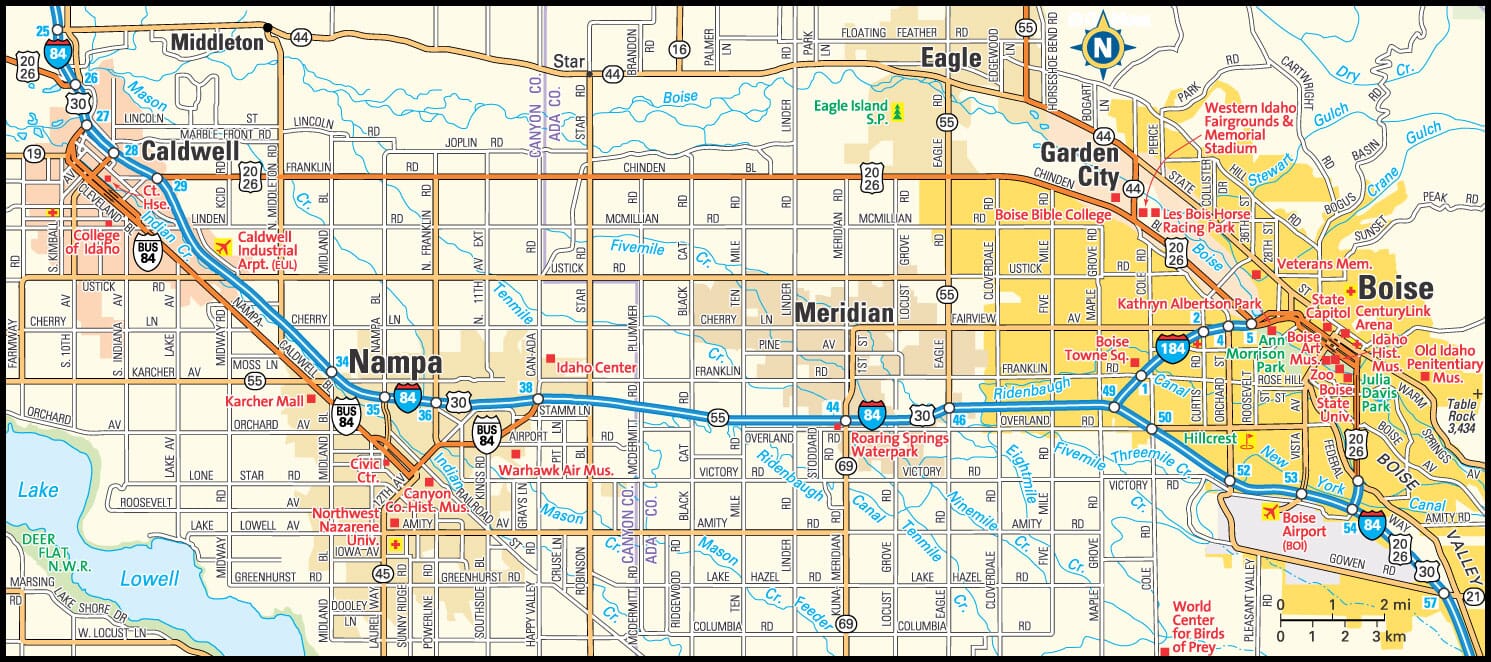
This Boise area map shows highways as well as major roads and points of interest in Idaho's capital city.

Boise, Idaho Area Map
Idaho Cities and Places *
Each city map page features a locator map plus demographic information about the specific city — as well as a directory of organizations in that Idaho city.- Boise, Idaho Map - Located at latitude 43.61 north and longitude 116.2 west, the city of Boise had a population of 216,282 at the 2010 census.
- Caldwell, Idaho Map - Located at latitude 43.66 north and longitude 116.69 west, the city of Caldwell had a population of 50,224 at the 2010 census.
- Coeur d Alene, Idaho Map - Located at latitude 47.68 north and longitude 116.78 west, the city of Coeur d Alene had a population of 47,912 at the 2010 census.
- Eagle, Idaho Map - Located at latitude 43.70 north and longitude 116.35 west, the city of Eagle had a population of 22,502 at the 2010 census.
- Garden City, Idaho Map - Located at latitude 43.62 north and longitude 116.24 west, the city of Garden City had a population of 11,420 at the 2010 census.
- Hayden, Idaho Map - Located at latitude 47.77 north and longitude 116.79 west, the city of Hayden had a population of 13,870 at the 2010 census.
- Idaho Falls, Idaho Map - Located at latitude 43.47 north and longitude 112.03 west, the city of Idaho Falls had a population of 58,691 at the 2010 census.
- Ketchum, Idaho Map - Located at latitude 43.68 north and longitude 114.36 west, the city of Ketchum had a population of 2,720 at the 2010 census.
- Lewiston, Idaho Map - Located at latitude 46.42 north and longitude 117.02 west, the city of Lewiston had a population of 32,482 at the 2010 census.
- Meridian, Idaho Map - Located at latitude 43.61 north and longitude 116.39 west, the city of Meridian had a population of 87,743 at the 2010 census.
- Nampa, Idaho Map - Located at latitude 43.54 north and longitude 116.56 west, the city of Nampa had a population of 88,211 at the 2010 census.
- Pocatello, Idaho Map - Located at latitude 42.87 north and longitude 112.47 west, the city of Pocatello had a population of 54,292 at the 2010 census.
- Post Falls, Idaho Map - Located at latitude 47.72 north and longitude 116.95 west, the city of Post Falls had a population of 29,896 at the 2010 census.
- Sandpoint, Idaho Map - Located at latitude 48.28 north and longitude 116.55 west, the city of Sandpoint had a population of 7,760 at the 2010 census.
- Twin Falls, Idaho Map - Located at latitude 42.56 north and longitude 114.46 west, the city of Twin Falls had a population of 46,528 at the 2010 census.
* A CDP — or census-designated place — is a concentration of population identified by the United States Census Bureau for statistical purposes.
Idaho Images from Pinterest
 |
 |
Major Cities in Each State
Copyright © 2011-2025Zeducorp. All rights reserved.
The Boise map hereon is © Globe Turner.
Terms and Conditions.
The Boise map hereon is © Globe Turner.
Terms and Conditions.