Indiana City Maps
City Maps > IN Cities
 This Indiana city maps page features a map of Indianapolis, the state's capital city; it also provides access to detailed maps of cities and other places that are located in Indiana.
Indiana has a land area of 35,823 square miles. The state's population density is about 181.0 residents per square mile.
Indianapolis Map
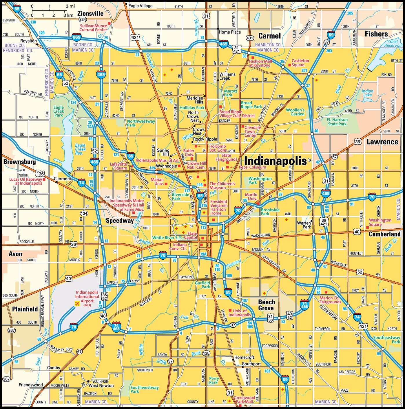
This Indianopolis area map shows highways as well as major roads and points of interest in Indiana's capital city.

Indianapolis, Indiana Area Map
Indiana Cities and Places *
Each city map page features a locator map plus demographic information about the specific city — as well as a directory of organizations in that Indiana city.- Anderson, Indiana Map - Located at latitude 40.11 north and longitude 85.68 west, the city of Anderson had a population of 55,455 at the 2010 census.
- Bloomington, Indiana Map - Located at latitude 39.17 north and longitude 86.53 west, the city of Bloomington had a population of 83,322 at the 2010 census.
- Bremen, Indiana Map - Located at latitude 41.45 north and longitude 86.15 west, the town of Bremen had a population of 4,589 at the 2010 census.
- Carmel, Indiana Map - Located at latitude 39.98 north and longitude 86.12 west, the city of Carmel had a population of 86,682 at the 2010 census.
- Columbus, Indiana Map - Located at latitude 39.20 north and longitude 85.92 west, the city of Columbus had a population of 46,124 at the 2010 census.
- Crown Point, Indiana Map - Located at latitude 41.42 north and longitude 87.37 west, the city of Crown Point had a population of 28,623 at the 2010 census.
- Dyer, Indiana Map - Located at latitude 41.49 north and longitude 87.52 west, the town of Dyer had a population of 16,169 at the 2010 census.
- Elkhart, Indiana Map - Located at latitude 41.68 north and longitude 85.98 west, the city of Elkhart had a population of 51,421 at the 2010 census.
- Evansville, Indiana Map - Located at latitude 37.97 north and longitude 87.56 west, the city of Evansville had a population of 120,346 at the 2010 census.
- Fishers, Indiana Map - Located at latitude 39.96 north and longitude 86.01 west, the town of Fishers had a population of 86,325 at the 2010 census.
- Fort Wayne, Indiana Map - Located at latitude 41.13 north and longitude 85.13 west, the city of Fort Wayne had a population of 258,522 at the 2010 census.
- Goshen, Indiana Map - Located at latitude 41.58 north and longitude 85.83 west, the city of Goshen had a population of 32,267 at the 2010 census.
- Greensburg, Indiana Map - Located at latitude 39.34 north and longitude 85.48 west, the city of Greensburg had a population of 11,817 at the 2010 census.
- Greenwood, Indiana Map - Located at latitude 39.61 north and longitude 86.11 west, the city of Greenwood had a population of 54,491 at the 2010 census.
- Griffith, Indiana Map - Located at latitude 41.53 north and longitude 87.42 west, the town of Griffith had a population of 16,516 at the 2010 census.
- Indianapolis, Indiana Map - Located at latitude 39.78 north and longitude 86.15 west, the city of Indianapolis had a population of 858,325 at the 2010 census.
- Jeffersonville, Indiana Map - Located at latitude 38.28 north and longitude 85.74 west, the city of Jeffersonville had a population of 46,440 at the 2010 census.
- Kokomo, Indiana Map - Located at latitude 40.49 north and longitude 86.13 west, the city of Kokomo had a population of 57,085 at the 2010 census.
- La Porte, Indiana Map - Located at latitude 41.61 north and longitude 86.72 west, the city of La Porte had a population of 22,007 at the 2010 census.
- Lafayette, Indiana Map - Located at latitude 40.42 north and longitude 86.88 west, the city of Lafayette had a population of 70,654 at the 2010 census.
- Martinsville, Indiana Map - Located at latitude 39.43 north and longitude 86.43 west, the city of Martinsville had a population of 11,744 at the 2010 census.
- Merrillville, Indiana Map - Located at latitude 41.48 north and longitude 87.33 west, the town of Merrillville had a population of 35,450 at the 2010 census.
- Michigan City, Indiana Map - Located at latitude 41.71 north and longitude 86.9 west, the city of Michigan City had a population of 31,487 at the 2010 census.
- Mishawaka, Indiana Map - Located at latitude 41.66 north and longitude 86.16 west, the city of Mishawaka had a population of 48,174 at the 2010 census.
- Mooresville, Indiana Map - Located at latitude 39.61 north and longitude 86.37 west, the town of Mooresville had a population of 9,576 at the 2010 census.
- Muncie, Indiana Map - Located at latitude 40.19 north and longitude 85.39 west, the city of Muncie had a population of 70,211 at the 2010 census.
- Munster, Indiana Map - Located at latitude 41.56 north and longitude 87.51 west, the town of Munster had a population of 23,103 at the 2010 census.
- New Albany, Indiana Map - Located at latitude 38.29 north and longitude 85.82 west, the city of New Albany had a population of 36,589 at the 2010 census.
- New Haven, Indiana Map - Located at latitude 41.07 north and longitude 85.01 west, the city of New Haven had a population of 15,608 at the 2010 census.
- Noblesville, Indiana Map - Located at latitude 40.05 north and longitude 86.01 west, the city of Noblesville had a population of 57,584 at the 2010 census.
- Richmond, Indiana Map - Located at latitude 39.83 north and longitude 84.89 west, the city of Richmond had a population of 36,159 at the 2010 census.
- Schererville, Indiana Map - Located at latitude 41.48 north and longitude 87.45 west, the town of Schererville had a population of 28,926 at the 2010 census.
- South Bend, Indiana Map - Located at latitude 41.68 north and longitude 86.25 west, the city of South Bend had a population of 101,190 at the 2010 census.
- Terre Haute, Indiana Map - Located at latitude 39.47 north and longitude 87.41 west, the city of Terre Haute had a population of 60,956 at the 2010 census.
- Valparaiso, Indiana Map - Located at latitude 41.47 north and longitude 87.06 west, the city of Valparaiso had a population of 32,369 at the 2010 census.
- West Lafayette, Indiana Map - Located at latitude 40.43 north and longitude 86.91 west, the city of West Lafayette had a population of 32,109 at the 2010 census.
- Westfield, Indiana Map - Located at latitude 40.04 north and longitude 86.13 west, the city of Westfield had a population of 35,297 at the 2010 census.
- Zionsville, Indiana Map - Located at latitude 39.95 north and longitude 86.26 west, the town of Zionsville had a population of 25,734 at the 2010 census.
* A CDP — or census-designated place — is a concentration of population identified by the United States Census Bureau for statistical purposes.
Indiana Images from Pinterest
 |
 |
Major Cities in Each State
Copyright © 2011-2025Zeducorp. All rights reserved.
The Indianapolis map hereon is © Globe Turner.
Terms and Conditions.
The Indianapolis map hereon is © Globe Turner.
Terms and Conditions.