Kansas City Maps
City Maps > KS Cities
 This Kansas city maps page features a map of Topeka, the state's capital city; it also provides access to detailed maps of cities and other places that are located in Kansas.
Kansas has a land area of 81,762 square miles. The state's population density is about 34.9 residents per square mile.
Topeka Map
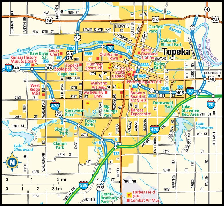
This Topeka area map shows highways as well as major roads and points of interest in Kansas' capital city.

Topeka, Kansas Area Map
Kansas Cities and Places *
Each city map page features a locator map plus demographic information about the specific city — as well as a directory of organizations in that Kansas city.- Andover, Kansas Map - Located at latitude 37.69 north and longitude 97.13 west, the city of Andover had a population of 12,509 at the 2010 census.
- Dodge City, Kansas Map - Located at latitude 37.75 north and longitude 100.02 west, the city of Dodge City had a population of 28,117 at the 2010 census.
- Garden City, Kansas Map - Located at latitude 37.97 north and longitude 100.87 west, the city of Garden City had a population of 27,004 at the 2010 census.
- Hays, Kansas Map - Located at latitude 38.88 north and longitude 99.33 west, the city of Hays had a population of 21,044 at the 2010 census.
- Hutchinson, Kansas Map - Located at latitude 38.06 north and longitude 97.93 west, the city of Hutchinson had a population of 41,642 at the 2010 census.
- Kansas City, Kansas Map - Located at latitude 39.11 north and longitude 94.63 west, the city of Kansas City had a population of 149,636 at the 2010 census.
- Leawood, Kansas Map - Located at latitude 38.97 north and longitude 94.62 west, the city of Leawood had a population of 34,395 at the 2010 census.
- Lenexa, Kansas Map - Located at latitude 38.95 north and longitude 94.73 west, the city of Lenexa had a population of 51,042 at the 2010 census.
- Manhattan, Kansas Map - Located at latitude 39.19 north and longitude 96.61 west, the city of Manhattan had a population of 56,078 at the 2010 census.
- Olathe, Kansas Map - Located at latitude 38.88 north and longitude 94.82 west, the city of Olathe had a population of 133,062 at the 2010 census.
- Overland Park, Kansas Map - Located at latitude 38.98 north and longitude 94.67 west, the city of Overland Park had a population of 184,525 at the 2010 census.
- Prairie Village, Kansas Map - Located at latitude 38.99 north and longitude 94.63 west, the city of Prairie Village had a population of 21,877 at the 2010 census.
- Salina, Kansas Map - Located at latitude 38.84 north and longitude 97.61 west, the city of Salina had a population of 47,867 at the 2010 census.
- Topeka, Kansas Map - Located at latitude 39.05 north and longitude 95.68 west, the city of Topeka had a population of 127,215 at the 2010 census.
- Wichita, Kansas Map - Located at latitude 37.69 north and longitude 97.34 west, the city of Wichita had a population of 388,413 at the 2010 census.
* A CDP — or census-designated place — is a concentration of population identified by the United States Census Bureau for statistical purposes.
Kansas Images from Pinterest
 |
 |
Major Cities in Each State
Copyright © 2011-2025Zeducorp. All rights reserved.
The Topeka map hereon is © Globe Turner.
Terms and Conditions.
The Topeka map hereon is © Globe Turner.
Terms and Conditions.