Louisiana City Maps
City Maps > LA Cities
 This Louisiana city maps page features a map of Baton Rouge, the state's capital city; it also provides access to detailed maps of cities and other places that are located in Louisiana.
Louisiana has a land area of 43,199 square miles. The state's population density is about 104.9 residents per square mile.
Baton Rouge Map
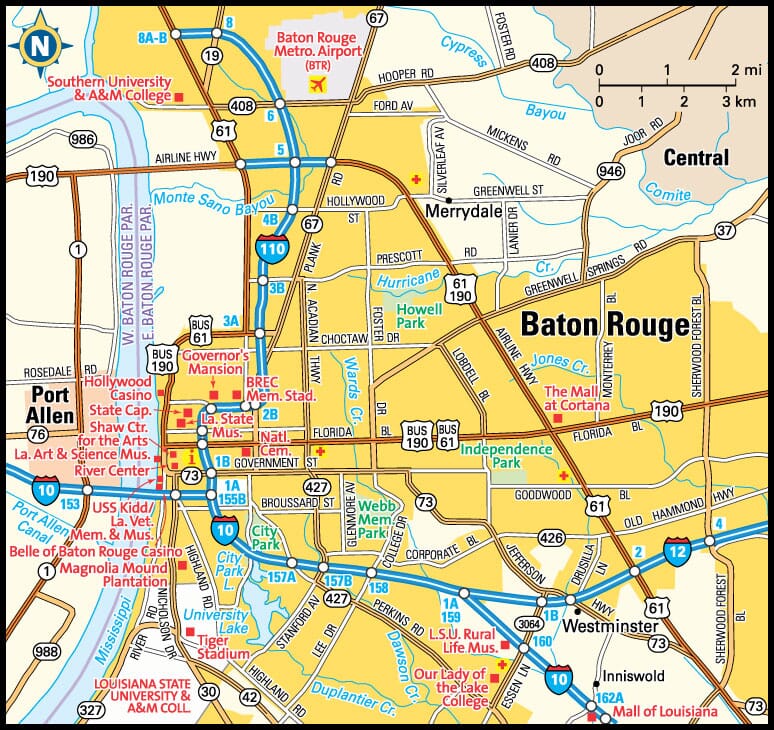
This Baton Rouge area map shows highways as well as major roads and points of interest in Louisiana's capital city.

Baton Rouge, Louisiana Area Map
Louisiana Cities and Places *
Each city map page features a locator map plus demographic information about the specific city — as well as a directory of organizations in that Louisiana city.- Alexandria, Louisiana Map - Located at latitude 31.31 north and longitude 92.45 west, the city of Alexandria had a population of 48,175 at the 2010 census.
- Baton Rouge, Louisiana Map - Located at latitude 30.45 north and longitude 91.15 west, the city of Baton Rouge had a population of 228,895 at the 2010 census.
- Bossier City, Louisiana Map - Located at latitude 32.52 north and longitude 93.73 west, the city of Bossier City had a population of 67,472 at the 2010 census.
- Covington, Louisiana Map - Located at latitude 30.48 north and longitude 90.1 west, the city of Covington had a population of 9,686 at the 2010 census.
- Gonzales, Louisiana Map - Located at latitude 30.24 north and longitude 90.92 west, the city of Gonzales had a population of 10,457 at the 2010 census.
- Gretna, Louisiana Map - Located at latitude 29.91 north and longitude 90.05 west, the city of Gretna had a population of 17,845 at the 2010 census.
- Hammond, Louisiana Map - Located at latitude 30.50 north and longitude 90.46 west, the city of Hammond had a population of 20,363 at the 2010 census.
- Harahan, Louisiana Map - Located at latitude 29.94 north and longitude 90.2 west, the city of Harahan had a population of 9,334 at the 2010 census.
- Harvey, Louisiana Map - Located at latitude 29.90 north and longitude 90.08 west, the CDP* of Harvey had a population of 21,247 at the 2010 census.
- Houma, Louisiana Map - Located at latitude 29.60 north and longitude 90.72 west, the city of Houma had a population of 34,124 at the 2010 census.
- Kenner, Louisiana Map - Located at latitude 29.99 north and longitude 90.24 west, the city of Kenner had a population of 67,064 at the 2010 census.
- Lafayette, Louisiana Map - Located at latitude 30.22 north and longitude 92.02 west, the city of Lafayette had a population of 126,066 at the 2010 census.
- Lake Charles, Louisiana Map - Located at latitude 30.23 north and longitude 93.22 west, the city of Lake Charles had a population of 74,889 at the 2010 census.
- Mandeville, Louisiana Map - Located at latitude 30.36 north and longitude 90.07 west, the city of Mandeville had a population of 12,236 at the 2010 census.
- Marrero, Louisiana Map - Located at latitude 29.90 north and longitude 90.1 west, the CDP* of Marrero had a population of 33,263 at the 2010 census.
- Metairie, Louisiana Map - Located at latitude 29.98 north and longitude 90.15 west, the CDP* of Metairie had a population of 140,074 at the 2010 census.
- Monroe, Louisiana Map - Located at latitude 32.51 north and longitude 92.12 west, the city of Monroe had a population of 49,601 at the 2010 census.
- Morgan City, Louisiana Map - Located at latitude 29.71 north and longitude 91.19 west, the city of Morgan City had a population of 11,943 at the 2010 census.
- New Iberia, Louisiana Map - Located at latitude 30.00 north and longitude 91.82 west, the city of New Iberia had a population of 30,745 at the 2010 census.
- New Orleans, Louisiana Map - Located at latitude 29.95 north and longitude 90.08 west, the city of New Orleans had a population of 384,320 at the 2010 census.
- Prairieville, Louisiana Map - Located at latitude 30.30 north and longitude 90.97 west, the CDP* of Prairieville had a population of 28,465 at the 2010 census.
- Shreveport, Louisiana Map - Located at latitude 32.47 north and longitude 93.79 west, the city of Shreveport had a population of 198,242 at the 2010 census.
- Slidell, Louisiana Map - Located at latitude 30.28 north and longitude 89.78 west, the city of Slidell had a population of 27,622 at the 2010 census.
- Sulphur, Louisiana Map - Located at latitude 30.24 north and longitude 93.38 west, the city of Sulphur had a population of 20,206 at the 2010 census.
- Thibodaux, Louisiana Map - Located at latitude 29.80 north and longitude 90.82 west, the city of Thibodaux had a population of 14,603 at the 2010 census.
- West Monroe, Louisiana Map - Located at latitude 32.52 north and longitude 92.15 west, the city of West Monroe had a population of 12,985 at the 2010 census.
* A CDP — or census-designated place — is a concentration of population identified by the United States Census Bureau for statistical purposes.
Major Cities in Each State
Copyright © 2011-2025Zeducorp. All rights reserved.
The Baton Rouge map hereon is © Globe Turner.
Terms and Conditions.
The Baton Rouge map hereon is © Globe Turner.
Terms and Conditions.