Maine City Maps
City Maps > ME Cities
 This Maine city maps page features a map of the state's capital city; it also provides access to detailed maps of cities and other places that are located in Maine.
Maine has a land area of 30,841 square miles. The state's population density is about 43.1 residents per square mile.
Augusta Map
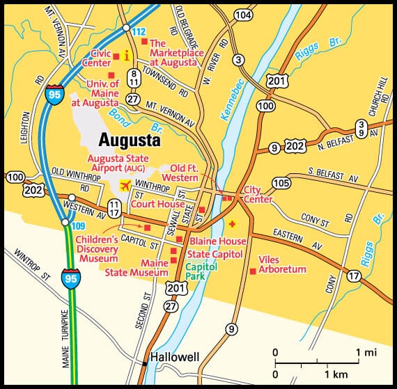
This Augusta area map shows highways as well as major roads and points of interest in Maine's capital city.

Augusta, Maine Area Map
Maine Cities and Places *
Each city map page features a locator map plus demographic information about the specific city — as well as a directory of organizations in that Maine city.- Auburn, Maine Map - Located at latitude 44.10 north and longitude 70.23 west, the city of Auburn had a population of 22,912 at the 2010 census.
- Augusta, Maine Map - Located at latitude 44.31 north and longitude 69.78 west, the city of Augusta had a population of 18,705 at the 2010 census.
- Bangor, Maine Map - Located at latitude 44.80 north and longitude 68.78 west, the city of Bangor had a population of 32,568 at the 2010 census.
- Bar Harbor, Maine Map - Located at latitude 44.40 north and longitude 68.26 west, the town of Bar Harbor had a population of 5,308 at the 2010 census.
- Bethel, Maine Map - Located at latitude 44.45 north and longitude 70.76 west, the town of Bethel had a population of 2,632 at the 2010 census.
- Biddeford, Maine Map - Located at latitude 43.49 north and longitude 70.45 west, the city of Biddeford had a population of 21,337 at the 2010 census.
- Boothbay Harbor, Maine Map - Located at latitude 43.85 north and longitude 69.64 west, the town of Boothbay Harbor had a population of 2,170 at the 2010 census.
- Camden, Maine Map - Located at latitude 44.22 north and longitude 69.06 west, the town of Camden had a population of 4,838 at the 2010 census.
- Ellsworth, Maine Map - Located at latitude 44.54 north and longitude 68.42 west, the city of Ellsworth had a population of 7,843 at the 2010 census.
- Falmouth, Maine Map - Located at latitude 43.74 north and longitude 70.28 west, the town of Falmouth had a population of 11,734 at the 2010 census.
- Freeport, Maine Map - Located at latitude 43.84 north and longitude 70.09 west, the town of Freeport had a population of 8,224 at the 2010 census.
- Gorham, Maine Map - Located at latitude 43.70 north and longitude 70.46 west, the town of Gorham had a population of 17,024 at the 2010 census.
- Kennebunkport, Maine Map - Located at latitude 43.37 north and longitude 70.43 west, the town of Kennebunkport had a population of 3,551 at the 2010 census.
- Lewiston, Maine Map - Located at latitude 44.10 north and longitude 70.21 west, the city of Lewiston had a population of 36,299 at the 2010 census.
- Old Orchard Beach, Maine Map - Located at latitude 43.53 north and longitude 70.36 west, the town of Old Orchard Beach had a population of 8,756 at the 2010 census.
- Portland, Maine Map - Located at latitude 43.66 north and longitude 70.26 west, the city of Portland had a population of 66,666 at the 2010 census.
- Rockland, Maine Map - Located at latitude 44.10 north and longitude 69.11 west, the city of Rockland had a population of 7,219 at the 2010 census.
- Rockport, Maine Map - Located at latitude 44.17 north and longitude 69.09 west, the town of Rockport had a population of 3,360 at the 2010 census.
- Saco, Maine Map - Located at latitude 43.50 north and longitude 70.44 west, the city of Saco had a population of 19,014 at the 2010 census.
- Scarborough, Maine Map - Located at latitude 43.57 north and longitude 70.33 west, the town of Scarborough had a population of 19,524 at the 2010 census.
- South Portland, Maine Map - Located at latitude 43.64 north and longitude 70.24 west, the city of South Portland had a population of 25,424 at the 2010 census.
- Wells, Maine Map - Located at latitude 43.31 north and longitude 70.63 west, the town of Wells had a population of 10,009 at the 2010 census.
* A CDP — or census-designated place — is a concentration of population identified by the United States Census Bureau for statistical purposes.
Maine Images from Pinterest
 |
 |
Major Cities in Each State
Copyright © 2011-2025Zeducorp. All rights reserved.
The Augusta map hereon is © Globe Turner.
Terms and Conditions.
The Augusta map hereon is © Globe Turner.
Terms and Conditions.