Missouri City Maps
City Maps > MO Cities
 This Missouri city maps page features a map of Jefferson City, the state's capital city; it also provides access to detailed maps of cities and other places that are located in Missouri.
Missouri has a land area of 68,716 square miles. The state's population density is about 87.2 residents per square mile.
Jefferson City Map
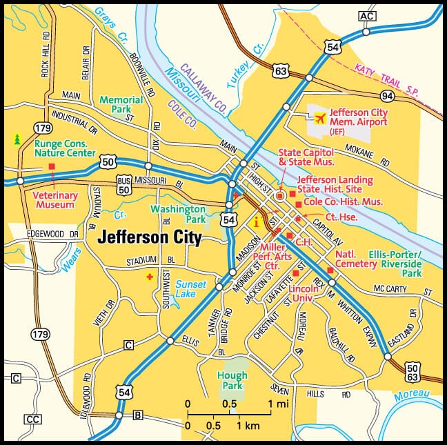
This Jefferson City area map shows highways as well as major roads and points of interest in Missouri's capital city.


Jefferson City, Missouri Area Map
Missouri Cities and Places *
Each city map page features a locator map plus demographic information about the specific city — as well as a directory of organizations in that Missouri city.- Arnold, Missouri Map - Located at latitude 38.43 north and longitude 90.38 west, the city of Arnold had a population of 21,243 at the 2010 census.
- Ballwin, Missouri Map - Located at latitude 38.60 north and longitude 90.55 west, the city of Ballwin had a population of 30,505 at the 2010 census.
- Belton, Missouri Map - Located at latitude 38.81 north and longitude 94.53 west, the city of Belton had a population of 23,165 at the 2010 census.
- Blue Springs, Missouri Map - Located at latitude 39.02 north and longitude 94.28 west, the city of Blue Springs had a population of 53,573 at the 2010 census.
- Branson, Missouri Map - Located at latitude 36.65 north and longitude 93.26 west, the city of Branson had a population of 11,340 at the 2010 census.
- Bridgeton, Missouri Map - Located at latitude 38.77 north and longitude 90.41 west, the city of Bridgeton had a population of 11,782 at the 2010 census.
- Camdenton, Missouri Map - Located at latitude 38.01 north and longitude 92.74 west, the city of Camdenton had a population of 3,844 at the 2010 census.
- Cape Girardeau, Missouri Map - Located at latitude 37.31 north and longitude 89.56 west, the city of Cape Girardeau had a population of 39,167 at the 2010 census.
- Carthage, Missouri Map - Located at latitude 37.18 north and longitude 94.31 west, the city of Carthage had a population of 14,271 at the 2010 census.
- Chesterfield, Missouri Map - Located at latitude 38.66 north and longitude 90.58 west, the city of Chesterfield had a population of 47,777 at the 2010 census.
- Clayton, Missouri Map - Located at latitude 38.64 north and longitude 90.32 west, the city of Clayton had a population of 15,882 at the 2010 census.
- Columbia, Missouri Map - Located at latitude 38.95 north and longitude 92.33 west, the city of Columbia had a population of 116,906 at the 2010 census.
- Ellisville, Missouri Map - Located at latitude 38.59 north and longitude 90.59 west, the city of Ellisville had a population of 9,253 at the 2010 census.
- Fenton, Missouri Map - Located at latitude 38.51 north and longitude 90.44 west, the city of Fenton had a population of 4,045 at the 2010 census.
- Festus, Missouri Map - Located at latitude 38.22 north and longitude 90.4 west, the city of Festus had a population of 11,885 at the 2010 census.
- Florissant, Missouri Map - Located at latitude 38.79 north and longitude 90.32 west, the city of Florissant had a population of 52,303 at the 2010 census.
- Grandview, Missouri Map - Located at latitude 38.89 north and longitude 94.53 west, the city of Grandview had a population of 25,290 at the 2010 census.
- Hazelwood, Missouri Map - Located at latitude 38.77 north and longitude 90.37 west, the city of Hazelwood had a population of 25,666 at the 2010 census.
- Independence, Missouri Map - Located at latitude 39.09 north and longitude 94.35 west, the city of Independence had a population of 117,494 at the 2010 census.
- Jefferson City, Missouri Map - Located at latitude 38.57 north and longitude 92.18 west, the city of Jefferson City had a population of 43,132 at the 2010 census.
- Joplin, Missouri Map - Located at latitude 37.08 north and longitude 94.5 west, the city of Joplin had a population of 51,316 at the 2010 census.
- Kansas City, Missouri Map - Located at latitude 39.13 north and longitude 94.55 west, the city of Kansas City had a population of 470,800 at the 2010 census.
- Lees Summit, Missouri Map - Located at latitude 38.92 north and longitude 94.38 west, the city of Lees Summit had a population of 93,864 at the 2010 census.
- Maryland Heights, Missouri Map - Located at latitude 38.71 north and longitude 90.43 west, the city of Maryland Heights had a population of 27,405 at the 2010 census.
- Nixa, Missouri Map - Located at latitude 37.04 north and longitude 93.29 west, the city of Nixa had a population of 20,570 at the 2010 census.
- O Fallon, Missouri Map - Located at latitude 38.81 north and longitude 90.7 west, the city of O Fallon had a population of 84,009 at the 2010 census.
- Osage Beach, Missouri Map - Located at latitude 38.14 north and longitude 92.65 west, the city of Osage Beach had a population of 4,395 at the 2010 census.
- Raymore, Missouri Map - Located at latitude 38.80 north and longitude 94.45 west, the city of Raymore had a population of 19,963 at the 2010 census.
- Raytown, Missouri Map - Located at latitude 39.01 north and longitude 94.46 west, the city of Raytown had a population of 29,481 at the 2010 census.
- Saint Charles, Missouri Map - Located at latitude 38.78 north and longitude 90.48 west, the city of Saint Charles had a population of 68,090 at the 2010 census.
- Saint Joseph, Missouri Map - Located at latitude 39.77 north and longitude 94.85 west, the city of Saint Joseph had a population of 76,967 at the 2010 census.
- Saint Louis, Missouri Map - Located at latitude 38.63 north and longitude 90.2 west, the city of Saint Louis had a population of 317,419 at the 2010 census.
- Sedalia, Missouri Map - Located at latitude 38.70 north and longitude 93.23 west, the city of Sedalia had a population of 21,492 at the 2010 census.
- Springfield, Missouri Map - Located at latitude 37.19 north and longitude 93.29 west, the city of Springfield had a population of 165,378 at the 2010 census.
- Sullivan, Missouri Map - Located at latitude 38.21 north and longitude 91.16 west, the city of Sullivan had a population of 7,054 at the 2010 census.
- Wentzville, Missouri Map - Located at latitude 38.81 north and longitude 90.85 west, the city of Wentzville had a population of 33,912 at the 2010 census.
* A CDP — or census-designated place — is a concentration of population identified by the United States Census Bureau for statistical purposes.
Missouri Images from Pinterest
 |
 |
Major Cities in Each State
Copyright © 2011-2025Zeducorp. All rights reserved.
The Jefferson City map hereon is © Globe Turner.
Terms and Conditions.
The Jefferson City map hereon is © Globe Turner.
Terms and Conditions.