Oklahoma City Maps
City Maps > OK Cities
 This Oklahoma city maps page features a map of Oklahoma City, the state's capital city; it also provides access to detailed maps of cities and other places that are located in Oklahoma.
Oklahoma has a land area of 68,603 square miles. The state's population density is about 54.7 residents per square mile.
Oklahoma City Map
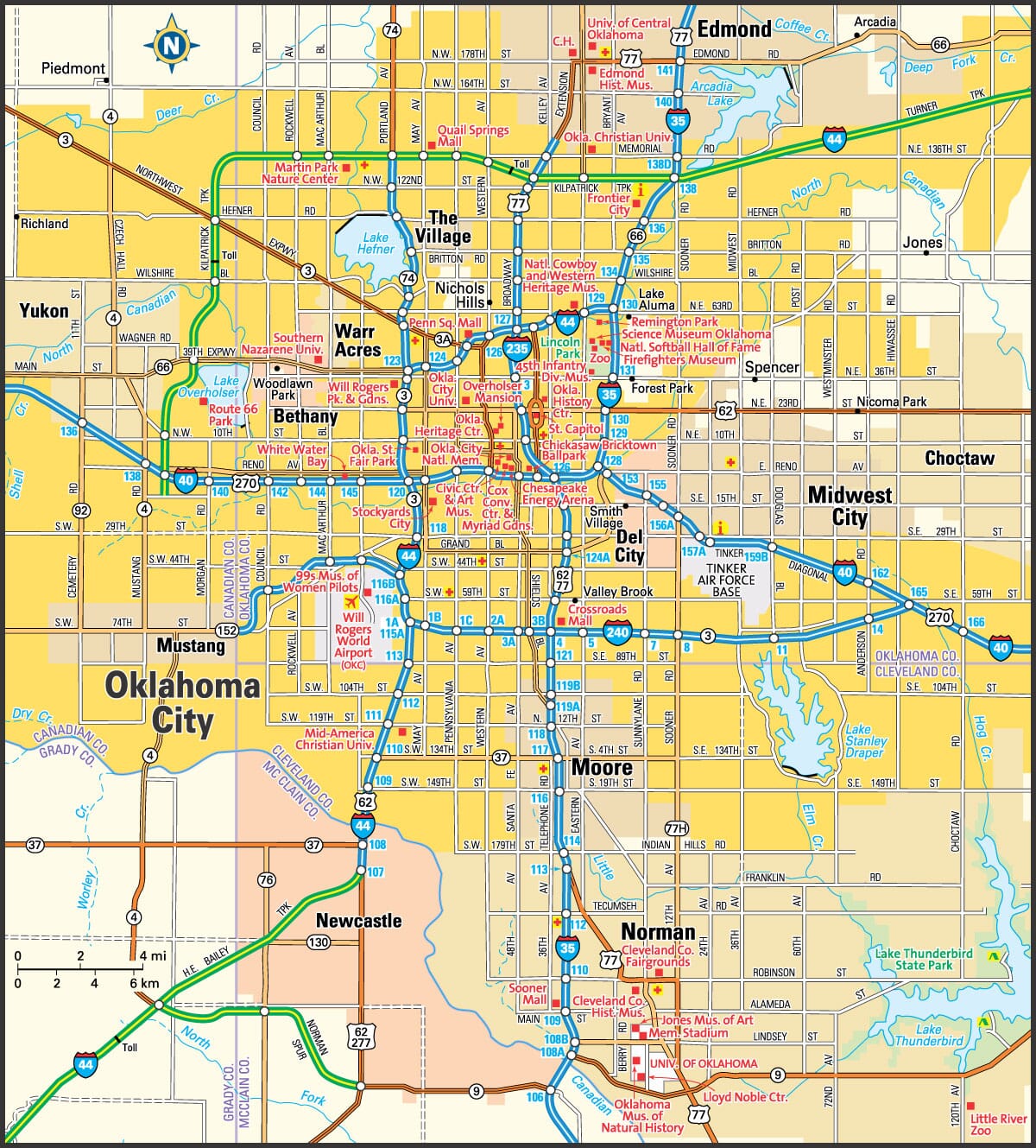
This Oklahoma City area map shows highways as well as major roads and points of interest in Oklahoma's capital city.

Oklahoma City, Oklahoma Area Map
Oklahoma Cities and Places *
Each city map page features a locator map plus demographic information about the specific city — as well as a directory of organizations in that Oklahoma city.- Ardmore, Oklahoma Map - Located at latitude 34.17 north and longitude 97.14 west, the city of Ardmore had a population of 25,226 at the 2010 census.
- Bartlesville, Oklahoma Map - Located at latitude 36.74 north and longitude 95.95 west, the city of Bartlesville had a population of 36,498 at the 2010 census.
- Bixby, Oklahoma Map - Located at latitude 35.95 north and longitude 95.87 west, the city of Bixby had a population of 24,008 at the 2010 census.
- Broken Arrow, Oklahoma Map - Located at latitude 36.04 north and longitude 95.78 west, the city of Broken Arrow had a population of 104,726 at the 2010 census.
- Edmond, Oklahoma Map - Located at latitude 35.65 north and longitude 97.48 west, the city of Edmond had a population of 88,605 at the 2010 census.
- Enid, Oklahoma Map - Located at latitude 36.40 north and longitude 97.88 west, the city of Enid had a population of 51,386 at the 2010 census.
- Lawton, Oklahoma Map - Located at latitude 34.61 north and longitude 98.39 west, the city of Lawton had a population of 97,017 at the 2010 census.
- Moore, Oklahoma Map - Located at latitude 35.34 north and longitude 97.49 west, the city of Moore had a population of 59,196 at the 2010 census.
- Muskogee, Oklahoma Map - Located at latitude 35.75 north and longitude 95.37 west, the city of Muskogee had a population of 38,616 at the 2010 census.
- Norman, Oklahoma Map - Located at latitude 35.22 north and longitude 97.44 west, the city of Norman had a population of 118,040 at the 2010 census.
- Oklahoma City, Oklahoma Map - Located at latitude 35.47 north and longitude 97.51 west, the city of Oklahoma City had a population of 620,602 at the 2010 census.
- Owasso, Oklahoma Map - Located at latitude 36.29 north and longitude 95.84 west, the city of Owasso had a population of 33,773 at the 2010 census.
- Sand Springs, Oklahoma Map - Located at latitude 36.14 north and longitude 96.13 west, the city of Sand Springs had a population of 19,553 at the 2010 census.
- Stillwater, Oklahoma Map - Located at latitude 36.12 north and longitude 97.06 west, the city of Stillwater had a population of 48,406 at the 2010 census.
- Tulsa, Oklahoma Map - Located at latitude 36.13 north and longitude 95.9 west, the city of Tulsa had a population of 399,682 at the 2010 census.
* A CDP — or census-designated place — is a concentration of population identified by the United States Census Bureau for statistical purposes.
Major Cities in Each State
Copyright © 2011-2026Zeducorp. All rights reserved.
The Oklahoma City map hereon is © Globe Turner.
Terms and Conditions.
The Oklahoma City map hereon is © Globe Turner.
Terms and Conditions.